It would seem reasonable for the G-8 to be expanded to include the world's second largest national economy - China.
Moreover, it would be useful to extend the invitation before China itself becomes the "G-1," by virtue of its explosive growth.
2008/07/08
2008/07/07
Responding to Mayor Hanneman’s Personal Attack
It is hard to recall a more foolish expenditure than that made by Mayor Mufi Hanneman of the city and county of Honolulu in a campaign of personal invective against me.
The Situation
Here is the remarkable story.
1. The Honolulu Advertiser published a letter from the mayor in which he noted Honolulu's superior carbon footprint rating as reported in a Brookings Institution report. In the letter he made a positive reference to the proposed Honolulu urban rail project, which he supports (Note 1, below).
2. When I became aware of the letter, I sent a "tongue in cheek" letter to the editor on the subject of Honolulu's carbon footprint, the point of which was to note that Honolulu's rating was both deserved and not deserved. I implied that Honolulu would not have scored so well if it had been founded on Michigan's Upper Peninsula (where much colder conditions would require far more energy for heating, and thus more CO2 emissions). I also gave Honolulu credit for its high transit market share, which despite having no rail has often equaled or exceeded the market shares of all urban areas in the nation, except for New York. My letter suggested that this favorable situation was not likely to be made any better by building the urban rail system (Note 2, below).
The Over-Reaction
The latter casual (though correct) comment in a letter not principally about urban rail led the Mayor to take out near-full page ads in two metropolitan newspapers on Sunday, June 22. The ad was run again on Monday in one of the newspapers. This costs money. The ads were directed in part at me, but also were highly critical of local rail system opponents. In a sense I suppose that I should take pride that the Mayor is so terrified that I might bring my analysis of his rail system to Honolulu.
Cause for Concern
I have no interest in responding to the Mayor’s ad hominem attacks.
Prudent public policy is often trumped by what the Germans call "realpolitic" (policy based on power rather than the public good). Indeed, when proponents of megaprojects stoop to ad hominem attacks it often tends to mask feeble analysis and facts that do not justify the large expenditures. However, it is the facts, not the personalities that matter. Personalizing the debate makes does nothing to make a questionable project less questionable.
The mayor's over-reaction at the prospect of my entering the policy debate should give pause. Local Honolulu analysts have already pointed out the grim reality --- that this extravagant rail line is likely to require more of a share of metropolitan area income than any in US history --- and by a long shot. One can only hope that the citizens of the city and county of Honolulu will have an opportunity to decide this issue at the ballot box, rather than having substantial tax increases imposed without their consent.
Wendell Cox
Principal, Demographia (St. Louis)
Visiting Professor, Conservatoire National des Arts et Metiers, Paris
Member, Los Angeles County Transportation Commission (1977-1985)
Member, Amtrak Reform Council (1999-2002)
Note 1:
MAYOR HANNEMAN'S LETTER TO THE HONOLULU ADVERTISER
No. 1 Ranking Report Confirms City Going in Right Direction
The new Brookings Institution report that ranked Honolulu No. 1 out of 100 U.S. cities for our low carbon emissions was great news, but we will not be content to rest on our laurels.
We're moving forward aggressively on many important initiatives to further protect our environment and enhance our quality of life.
Our rail transit project is exactly what's needed to provide key improvements cited by the study to reduce pollution: Promote more transportation choices and transit-oriented development.
The study found that cities with rail mass transit systems and densely populated urban cores have far smaller "carbon footprints" per capita than sprawling metropolitan areas dependent on private vehicles. Our rail system will give thousands of commuters and visitors an alternative to private vehicles and clogged freeways, while providing important opportunities for new housing, commercial space and public facilities along the rail line.
Our 21st Century Ahupua'a Plan closely examined other environmentally friendly policies, and they are now reaching fruition. We're continually expanding curbside residential recycling, replacing buses and police cars with efficient hybrid vehicles, increasing the capacity of the H-Power garbage-to-energy plant, operating ferries from Kalaeloa to Aloha Tower and adding bicycle lanes to our roadways.
A few will always nit-pick when good news is announced, but we're confident that the Brookings report provided an honest assessment of Honolulu's ranking and made it clear that we are moving in the right direction with rail transit and other important initiatives. Our goal remains to leave Honolulu better than we found it.
Mayor Mufi Hannemann
City and County of Honolulu
Note 2
MY LETTER TO THE HONOLULU ADVERTISER (June 2)
To the Editor
The Honolulu Advertiser
The Mayor boasts about Honolulu's superior carbon footprint and some boasting is appropriate.
It is no surprise that Honolulu has one of the smaller transportation footprints in the nation. With its bus system, Honolulu often ranks second in the nation in transit market share to the New York area. It is hard to imagine that the proposed, expensive rail system will make that any better.
As for residential energy, had the city founders instead chosen a location on Michigan's Upper Peninsula, things would look much worse. Honolulu's modest residential carbon footprint is a function of Hawaii's marvelous climate, which reduces energy demand substantially.
Sincerely,
Wendell Cox
Principal, Demographia, St. Louis
2008/06/28
World Urban Areas: Population, Density & Projections Released
http://www.demographia.com/db-worldua.pdf
Demographia announces publication of World Urban Areas & Population Projections. World Urban Areas & Population Projections remains the only known source in the world for comprehensive and consistent estimates of urban land area and densities. This 4th comprehensive edition replaces publications released in March of 2007. The product includes:
(1) Population, land area and density estimates for all 723 identified urban agglomerations in the world with 500,000 or more in population. In all, 1,316 urban areas are included, representing 50 percent of the world urban population. Tables are provided in population, land area, population density and alphabetical order.
(2) There is also a summary of the data by the largest nations and major world regions.
(3) Population projections for all 204 urban agglomerations anticipated to have 2,000,000 or more residents in 2025. There is also a projection of the 2008 population of all such urban areas. Tables are provided in alphabetical order and population order by 2008 and 2025 projections
2008/06/23
Consultant Memo on Houston Misleads Tauranga Council
A Tauranga Councillor (New Zealand) raised questions about “smart growth” (prescriptive land use planning) in relation to the superior housing affordability of Houston, where no such policies exist. The resulting memorandum in response is evaluated below.
Principal Points
1. All of Texas is affordable and most of Texas is unzoned.
2. Houston’s affordable housing is not just on the urban fringe, contrary to the statement in the memo.
3. Houston’s suburbanization (or “sprawl”) is about average and not much greater than Portland’s.
4. Houston’s traffic congestion has been materially improved by road construction.
5. Houston’s traffic moves considerably faster than Auckland’s.
6. The loss of housing affordability is associated with smart growth-style land use policies.
Houston and Texas: Superior Housing Affordability
The city of Houston (local government authority) has no zoning, which the memo rightly points out. Virtually all of the other local government authorities in the Houston metropolitan area have zoning. However, most of the land in the Houston metropolitan area is unzoned, because it is outside local government authority areas and under the jurisdiction of counties. In Texas, counties have no zoning power. Thus, while local government authorities in Texas outside the city of Houston generally have zoning, they are forced to operate in a competitive environment under which housing can be readily built, without zoning, in adjacent unincorporated areas. Indeed, given this competitive environment, it is appropriate to think of the state of Texas as unzoned (environmental regulation, which is established at the state and federal level is observed).
The memo notes that Dallas (actually the Dallas-Fort Worth metropolitan area) has slightly better housing affordability than the Houston metropolitan area as measured by the Median Multiple (median house price divided by the median household income). The important point is that both metropolitan areas are below the historic maximum norm of 3.0. By comparison, the Median Multiple in Tauranga was 7.5 in the third quarter of 2007 (Auckland was 6.9). This means that residents of these New Zealand urban centres face relative home ownership costs more than 2.5 times those of Houston, Dallas-Fort Worth and a number of US and Canadian metropolitan areas that have not adopted smart growth policies.
Affordable Housing in Houston: Not Limited to the Fringe
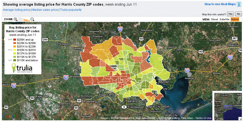
The memo indicates that housing is affordable only on Houston’s fringe. This is absurd and betrays an acute unfamiliarity with Houston housing markets. The referenced map shows house asking prices in Harris County (which is core of the urban area). Affordable housing is to be found throughout the metropolitan area Indeed, the low bound of the highest price category is lower than the median house price in Tauranga. No one would expect the consultant to have expertise on Houston housing markets. It does seem inappropriate, however, for the consultant to be erroneously opining that affordable housing is available only on the fringe
Houston’s "Sprawl:" Like Portland
As for Houston's suburbanization, (pejoratively called "sprawl,") the urban area (urban footprint) is approximately average the density for a US urban area over 1,000,000. It is only 10 percent less dense than Portland, despite that urban area's strong smart growth policies. Houston’s density is virtually the same as that of Dallas-Fort Worth and a quarter higher than that of Boston.
Traffic Congestion: Road Building Made it Better
The memo cites Houston as having some of the nation’s worst traffic congestion. It does --- the latest data shows that Houston ranks 8th in traffic congestion, which is not surprising for the nation’s 6th largest metropolitan area. Houston has done quite well. According to the Texas Transportation Institute (leading authority in the US on the subject), Houston had the worst traffic congestion in the US in the middle 1980s (among urban areas of more than 1,000,000 population). After a strong road building program, traffic congestion was materially reduced (though has increased in more recent years, since the road construction program has not kept up with population growth). By the mid-1990s, Houston had improved to 23rd place.
Since the middle 1990s, population growth has outstripped highway expansion and Houston has risen back to rank 8th in traffic congestion (Houston is one of the three fastest growing metropolitan areas over 5,000,000 population in the high income world). Houston has done better than smart growth Portland over the past 20 years, which has seen its excess peak hour traffic delay (based on the Travel Time Index) rise from approximately 1/4 that of Houston to 3/4 that of Houston.
Houston Traffic Moves Faster than Auckland Traffic
Finally, average travel speeds on the motorway and arterial network in Houston were more than 60 kph in 2002 (latest data from the Texas Transportation Institute). By comparison, according to the New Zealand Travel Time Indicator report, the average peak period travel times on the motorway and arterial network of Auckland was 36 kph in 2007.
Smart Growth Land Use Policy: The Root of New Zealand’s Unaffordable Housing
The report misses the point that New Zealand’s housing affordability loss is the result of overly prescriptive land use planning (smart growth or urban consolidation policy). This connection has been identified by some of the world’s top economists and is detailed in our 4th Annual Demographia International Housing Affordability Survey. The situation was best summed up by former Reserve Bank of New Zealand Governor Donald Brash, writing in the Demographia report: the affordability of housing is overwhelmingly a function of just one thing, the extent to which governments place artificial restrictions on the supply of residential land.. In short, where there are no prescriptive land use policies, housing is affordable. Among the six nations surveyed in our report, there are no exceptions.
Addendum: Understanding US Urban Geography
The memo exhibits the usual (and understandable) confusion about US urban geography. The memo refers to the city of Houston (which is a local government authority or municipality of 2 million population). The referenced housing affordability measures apply to the metropolitan area, which has 5.5 million people. There is also the Houston urban area (or agglomeration), which has more than 4,000,000 people (the difference between the agglomeration and the metropolitan area is that the urban area is the continuous urbanization (or urban footprint), while the metropolitan area includes areas considered in the labor market that are outside the urban area and generally in rural areas. Urban area and metropolitan area are formal designations by the US Bureau of the Census.
Principal Points
1. All of Texas is affordable and most of Texas is unzoned.
2. Houston’s affordable housing is not just on the urban fringe, contrary to the statement in the memo.
3. Houston’s suburbanization (or “sprawl”) is about average and not much greater than Portland’s.
4. Houston’s traffic congestion has been materially improved by road construction.
5. Houston’s traffic moves considerably faster than Auckland’s.
6. The loss of housing affordability is associated with smart growth-style land use policies.
Houston and Texas: Superior Housing Affordability
The city of Houston (local government authority) has no zoning, which the memo rightly points out. Virtually all of the other local government authorities in the Houston metropolitan area have zoning. However, most of the land in the Houston metropolitan area is unzoned, because it is outside local government authority areas and under the jurisdiction of counties. In Texas, counties have no zoning power. Thus, while local government authorities in Texas outside the city of Houston generally have zoning, they are forced to operate in a competitive environment under which housing can be readily built, without zoning, in adjacent unincorporated areas. Indeed, given this competitive environment, it is appropriate to think of the state of Texas as unzoned (environmental regulation, which is established at the state and federal level is observed).
The memo notes that Dallas (actually the Dallas-Fort Worth metropolitan area) has slightly better housing affordability than the Houston metropolitan area as measured by the Median Multiple (median house price divided by the median household income). The important point is that both metropolitan areas are below the historic maximum norm of 3.0. By comparison, the Median Multiple in Tauranga was 7.5 in the third quarter of 2007 (Auckland was 6.9). This means that residents of these New Zealand urban centres face relative home ownership costs more than 2.5 times those of Houston, Dallas-Fort Worth and a number of US and Canadian metropolitan areas that have not adopted smart growth policies.
Affordable Housing in Houston: Not Limited to the Fringe
The memo indicates that housing is affordable only on Houston’s fringe. This is absurd and betrays an acute unfamiliarity with Houston housing markets. The referenced map shows house asking prices in Harris County (which is core of the urban area). Affordable housing is to be found throughout the metropolitan area Indeed, the low bound of the highest price category is lower than the median house price in Tauranga. No one would expect the consultant to have expertise on Houston housing markets. It does seem inappropriate, however, for the consultant to be erroneously opining that affordable housing is available only on the fringe
Houston’s "Sprawl:" Like Portland
As for Houston's suburbanization, (pejoratively called "sprawl,") the urban area (urban footprint) is approximately average the density for a US urban area over 1,000,000. It is only 10 percent less dense than Portland, despite that urban area's strong smart growth policies. Houston’s density is virtually the same as that of Dallas-Fort Worth and a quarter higher than that of Boston.
Traffic Congestion: Road Building Made it Better
The memo cites Houston as having some of the nation’s worst traffic congestion. It does --- the latest data shows that Houston ranks 8th in traffic congestion, which is not surprising for the nation’s 6th largest metropolitan area. Houston has done quite well. According to the Texas Transportation Institute (leading authority in the US on the subject), Houston had the worst traffic congestion in the US in the middle 1980s (among urban areas of more than 1,000,000 population). After a strong road building program, traffic congestion was materially reduced (though has increased in more recent years, since the road construction program has not kept up with population growth). By the mid-1990s, Houston had improved to 23rd place.
Since the middle 1990s, population growth has outstripped highway expansion and Houston has risen back to rank 8th in traffic congestion (Houston is one of the three fastest growing metropolitan areas over 5,000,000 population in the high income world). Houston has done better than smart growth Portland over the past 20 years, which has seen its excess peak hour traffic delay (based on the Travel Time Index) rise from approximately 1/4 that of Houston to 3/4 that of Houston.
Houston Traffic Moves Faster than Auckland Traffic
Finally, average travel speeds on the motorway and arterial network in Houston were more than 60 kph in 2002 (latest data from the Texas Transportation Institute). By comparison, according to the New Zealand Travel Time Indicator report, the average peak period travel times on the motorway and arterial network of Auckland was 36 kph in 2007.
Smart Growth Land Use Policy: The Root of New Zealand’s Unaffordable Housing
The report misses the point that New Zealand’s housing affordability loss is the result of overly prescriptive land use planning (smart growth or urban consolidation policy). This connection has been identified by some of the world’s top economists and is detailed in our 4th Annual Demographia International Housing Affordability Survey. The situation was best summed up by former Reserve Bank of New Zealand Governor Donald Brash, writing in the Demographia report: the affordability of housing is overwhelmingly a function of just one thing, the extent to which governments place artificial restrictions on the supply of residential land.. In short, where there are no prescriptive land use policies, housing is affordable. Among the six nations surveyed in our report, there are no exceptions.
Addendum: Understanding US Urban Geography
The memo exhibits the usual (and understandable) confusion about US urban geography. The memo refers to the city of Houston (which is a local government authority or municipality of 2 million population). The referenced housing affordability measures apply to the metropolitan area, which has 5.5 million people. There is also the Houston urban area (or agglomeration), which has more than 4,000,000 people (the difference between the agglomeration and the metropolitan area is that the urban area is the continuous urbanization (or urban footprint), while the metropolitan area includes areas considered in the labor market that are outside the urban area and generally in rural areas. Urban area and metropolitan area are formal designations by the US Bureau of the Census.
2008/06/14
On the Success of Airline Deregulation
Missing the Point
Re: Airline Deregulation Article: April 17
http://www.nytimes.com/2008/04/17/business/17air.html
To Micheline Maynard
New York Times
Just saw your column in the New York Times.
Perhaps I missed something, but it is astounding that you could have written an article assessing airline deregulation and not have prominently mentioned the impacts on consumers --- that deregulation has been associated with a huge increase in passenger usage, that simply could not have happened in the regulated environment.
This article seems to convey a much greater concern about producers than consumers. Businesses and society, in the final analysis, exist for the good of consumers and by that standard, airline deregulation has been a huge success.
Best regards,
Wendell Cox
Principal, Demographia (St. Louis)
Visiting Professor, Conservatoire National des Arts et Metiers (Paris)
2008/06/03
Historic Annapolis Core Threatened by New Urbanist Interloper
A City Struggles To Find Its Niche: Competition Has Annapolis Planners Pondering How to Save Downtown
New urbanists have long claimed to admire traditional urban cores (downtowns) and sought to replicate them in new developments. However, their admiration of genuine urbanism is shown to be wanting, as revealed by the opening of the Annapolis Town Centre, which today’s Washington Post indicates is not only not in Annapolis, but could well decimate the already struggling, genuine core of Annapolis.
Thus, the contempt that new urbanists have toward how the majority of people have chosen to live, appears to extend to the very districts they claim to adore. It may be that new urbanism is more about securing fees for architects than maintaining urban cores
Transit Ridership Increase in Context
Note to Lena Sun of the Washington Post
Re June 3 article
In context, the transit increase represents somewhere around 5 percent of the urban driving decline... which indicates that while driving is down, transit's ridership increase is up only a fraction of the decline.
Best regards,
Wendell Cox
Principal Demographia
Former Member, Los Angeles County Transportation Commission
Visiting Professor, Conservatoire National des Arts et Metiers
Lucky Honolulu Wasn't Founded on Upper Peninsula: The Brookings Metropolitan Carbon Footprint Report
Re: Mayor Hanneman Letter
June 2, 2008
To the Editor
The Honolulu Advertiser
The Mayor boasts about Honolulu’s superior carbon footprint and some boasting is appropriate.
It is no surprise that Honolulu has one of the smaller transportation footprints in the nation. With its bus system, Honolulu often ranks second in the nation in transit market share to the New York area. It is hard to imagine that the proposed, expensive rail system will make that any better.
As for residential energy, had the city founders instead chosen a location on Michigan’s Upper Peninsula, things would look much worse. Honolulu’s modest residential carbon footprint is a function of Hawaii’s marvelous climate, which reduces energy demand substantially.
Sincerely,
Wendell Cox
Principal, Demographia, St. Louis
Alex Marshall's Delusions About Anti-Transit Bias
Letter to the Editor
Hartford Courant
June 9, 2008
Response To 'Idealism Takes A Wrong Turn'
June 9, 2008
In response to Alex Marshall's June 1 Place article, "Idealism Takes A Wrong Turn," in which he criticized my views on cars and transit:
Marshall deludes himself about a bias toward highways and against mass transit. Indeed, government transit spending per passenger mile is nearly $0.95, while all government spending on roadways is less than $0.04. Some bias. Transit spending is 25 times highway spending. This does not consider the fact that roads carry a large share of the nation's freight. Transit carries none.
Further, government highway spending is principally from gasoline taxes on drivers, not subsidies from non-users. In contrast, more than 75 percent of transit spending comes from non-user subsidies.
Ending the bias would require transit to be funded by taxes on transit fares. This, of course, would be the end of transit.
Despite romantic notions to the contrary, we cannot replace the mobility of the automobile. This is not to deny transit's important roles in serving low-income households in city cores and its principal niche market, the 10 percent of jobs that are in downtown areas.
The unparalleled democratization of prosperity (read, poverty reduction) in Western Europe and the United States since World War II could not have happened without the mobility of the automobile and the new, owner-occupied houses on cheap suburban land.
Wendell Cox
Principal Demographia Metropolitan St. Louis Belleville, Ill.
The writer was a member of the Los Angeles County Transportation Committee, 1977-85.
2008/06/01
GHG Emissions Less in Auto Oriented Suburbs than Urban Cores: Australia
Deflating the Myths on Greenhouse Gas Emissions
Policy Conclusions: This report summarizes the data developed by the Australian Conservation Foundation in its Conservation Atlas. This nearly 100-page report provides detailed information by local authority area (geographical sector) of Australia’s largest urban areas. The conclusions are different than would have been anticipated.
Lower GHG emissions are associated with urban fringe locations, not the core.
Lower GHG emissions are associated with higher rates of detached housing.
Lower GHG emissions are associated with greater automobile use.
Lower GHG emissions are associated with lower population density.
Repealing the “Great Australian Dream”? Climate change concerns have propelled the issue of reducing greenhouse gas emissions to the top of the public policy agenda. For some years the urban planning community and other interests have sought to contain urban expansion (pejoratively called “urban sprawl”) and force more dense development through policies referred to as “smart growth” or “urban consolidation.” There is a presumed preference for multi-unit residential development in city cores and an aversion against low-priced detached housing on the urban fringe. An important objective of these policies has been to reduce automobile use, which it is assumed will naturally occur as a result of higher urban densities,
In Australia, these policies have seriously limited the availability of market priced land on the urban fringe and driven house prices up at a far greater rate than has occurred in international urban areas where compact city policies have not been implemented. Thus, the present dominant policies are at odds with the “Great Australian Dream,” which has been based upon detached housing on the fringe and automobile access.
Smart Growth and GHG Emissions: The urban consolidation agenda is perceived by many to be an appropriate strategy for reducing GHG emissions. Part of this is due to the fact that automobiles are an obvious example of fossil fuel use.
Generally, urban planning policy assumes that greenhouse gas emissions are higher in portions of urban areas that are more suburban, especially areas in which there is a preponderance of single-family detached housing. There is also the assumption that greenhouse gas emissions are lower in higher density areas, especially where there are more high-rise condominium and apartment buildings. And, as noted above, a parallel perception is that greenhouse gas emissions are greater in portions of the urban area that rely more on cars, and less where there is greater dependence on public transport. Finally, higher population densities are associated with lower GHG emissions.
The Reality: However, reducing GHG emissions is not so simple as to be achieved through the urban consolidation agenda. Indeed, there is considerable evidence to the contrary.
GHG emission estimates from the recently published Australian Conservation Foundation Consumption Atlas, indicates virtually the opposite of the generally held perceptions. The data shows that lower density areas, which rely more on automobiles, tend to produce less in GHG emissions than the high density, more public transport dependent areas that are favored by urban consolidation policies.
The reality, as indicated by data from the Australian Conservation Foundation’s Consumption Atlas is virtually the opposite.
The Consumption Atlas: The Consumption Atlas relies on a holistic approach, which allocates greenhouse gas emissions to final consumption at the household level. This includes not only direct energy consumption (such as household electricity use and automobile use) but also a much larger component, indirect energy consumption, which includes GHG emissions from electricity generation, manufacturing, processing, transport and otherwise producing consumer products. The Consumption Atlas provides a groundbreaking model for GHG emission analysis that establishes a model for the field, not only for Australia but also around the world.
The approach of the Consumption Atlas avoids what could deteriorate into agenda-driven approaches that focus only on the particular GHG producing sectors that are in the political sites of interest groups. Any approach that begins at any level other than allocating all GHG emissions to specific final consumption runs this risk. For example, the authors note that emphasis on direct consumption (such as automobile use and land use policy) may be “misdirected since direct energy use constitutes remarkably small portion of the total energy requirement over a range of incomes.”
The more important risk is that agenda-driven policies may fail to achieve the objective of substantially reducing GHG emissions. Any serious, good faith program for reducing emissions must be based upon comprehensive analysis that does not begin with pre-conceived notions, despite their popularity even at the highest policy levels.
Note: This report was prepared by Demographia for the Residential Development Council of the Property Council of Australia.
2008/05/24
Windows XP Machines Still Being Sold
For anyone resistant to converting to “Windows Vista” from “Windows XP,” there is still an alternative. Dell continues to sell new computers, desktops and laptops, loaded with Windows XP (www.dell.com). Reportedly, some other manufacturers are doing the same. The Dell prices are competitive with prices at major retailers, where only Windows Vista loaded machines are for sale.
There are also reports that “downgrades” to Windows XP can be obtained for some Windows Vista machines, however the process as described on the internet may not be as simple as some might like.
There are two good reasons for postponing the switch from Windows XP to Windows Vista.
1. There are continuing complaints about Vista. They are so intense that competitor Apple has run television advertisements about Vista.
2. Many older programs will simply not work on Windows Vista. In the longer run, people using such programs will need to migrate to the new operating systems (or to alternatives, such as Linux or Apple). However, the new 2007 Microsoft Office product, which features Word, Power Point and Excel runs on both Windows XP and Windows Vista, so that additional time can be taken to adjust to the emerging Windows environment without having to make a complete break with Windows XP and the many years of PC compatibility that Microsoft appears to value so little.
A final, less compelling reason for resisting the change is to “vote” against Microsoft’s recurrent practice of unveiling new operating systems “before their time.” Planned or forced obsolescence is in no-one’s best interests except that of a firm seeking to maximize its revenues by undermining the interests of its customers. This is why, in the longer run, Microsoft, will face market share losses that are likely to be swift and significant, if serious competition ever emerges. So far, Apple is not even a threat (regrettably).
Thus, this is no advertisement for Apple, to which I attempted to switch a few years ago in an expensive experiment. One afternoon about a month after switching, I realized that I was more productive on a French language keyboard (with its extra letters, requirements to hold down more than one key for some letters and default special character set rather than numbers on the top row) than on an Apple US-English keyboard. That realization resulted in the Apple being boxed up within minutes (as soon as I could copy the nwere files to my older PC), and I have never looked back. My sister in Alaska, who had long wanted an Apple, was well pleased.
2008/05/03
Paris Light Rail (Tram) Increases Greenhouse Gas Emissions
According to University of Paris researchers, the new (2007) Paris tramway (light rail or streetcar) along the south boulevards des Maréchaux has attracted, at most, 3 percent of its ridership from cars. This finding is made in a paper entitled Paris: un tramway nommé désir (Paris: A Streetcar Named Desire), published in August 2007 by Rémy Prud’homme, Martin Koenig, Pierre Kopp. The authors note that this small modal shift “once again shows the limits of modal shift strategies” (our liberal interpretation of the French).
While traffic along the boulevard has been reduced, this has been accomplished by narrowing the capacity and forcing traffic to parallel roadways. The result has been to increase traffic congestion and, as occurs when traffic becomes slower and more erratic, increase fuel consumption, which of course leads to higher greenhouse gas emissions. It is estimated the tramway has resulted in a net increase of nearly 40,000 tonnes of CO2 annually.
Finally, the social costs of the project are estimated to have exceeded the benefits.
2008/05/02
Ken's Loss is London's Gain
Paris (20080502): The Evening Standard reports that Ken Livingstone is history as mayor of London. Boris Johnson, the Conservative (Tory) candidate is reported to have won the election convincingly .
This is an important victory for rational transport policy. Johnson is a “somewhat” critic of Livingstone’s radical congestion charging plan (implemented in 2003), which requires a payment of ₤8.00 ($16.00) for each car entry to central London between 07:00 and 18:00 on work days. Livingstone had announced plans for much higher tolls to be levied later in the year based upon the pollution rating of car models.
The congestion charging zone was expanded to the west in 2007 and has proven relatively ineffective. Johnson has promised to dismantle the expansion, returning the congestion charging zone to its original, smaller geographical definition. He would also reduce the charge, cancel the planned increases and charge based upon time of day and length of stay. No longer would it cost $16 to “pop” across the cordon to buy Al Gore’s proverbial quart of milk.
Remy Prud’homme and colleagues from the University of Paris have shown than the social cost of operating London’s congestion charge system exceeds the benefits.
The Daily Telegraph published my commentary expressing concerns about the congestion charge scheme the morning it was implemented. Those concerns remain and it would appear that a Johnson mayoralty will begin to round the rough edges of what has to be one of the most arbitrary transport policies in history (Commentary 2003.02.16.
Finally, Johnson would phase out the “bendy-buses” (articulated buses) that Livingstone had used to replace double deck buses. One problem with the bendy-buses is that their length makes boarding difficult at bus stops where many buses often line up. Of course, this also increases traffic congestion.
2008/04/11
FHWA Overstates Houston Driving by 50 Percent --- Again
New (2006) Federal Highway Administration data for urban area highway use has just been released. As usual, the Houston area is wrongly shown as having the highest daily vehicle miles traveled per person among the nation’s urbanized areas of more than 1,000,000.
The erroneous 36.0 miles per capita is the result of a reported urbanized area (urban footprint) population of 2.8 million and a daily travel figure of 101 million miles. This 2.8 million population is reported to live in 1,476 square miles.
In 2000, FHWA reported Houston’s urbanized area population to be 2.5 million in an area of 1,537 square miles. The same year, the US Bureau of the Census found the Houston urbanized area to cover 1,295 square miles and to have a population of 3.8 million --- a full 1.3 million above the FHWA number. It is, of course, impossible for the FHWA’s larger urbanized area to have 1.3 million fewer people than that of the census. The result was then, and is today, a huge over-estimation of the daily vehicle miles traveled per capita.
Some years ago I brought this issue to the attention of the United States Department of Transportation. A bureaucrat condescendingly wrote me that Census urbanized areas and FHWA urbanized areas were different things, not comprehending the irreconcilable and irrational differences I had pointed out. There used to be similar problems with the Atlanta data, but it has since been fixed. In 2003, FHWA reported Atlanta at 34 miles per capita daily and, now, having adjusted its population estimate to a more rational figure. Daily travel is now reported at 29 miles per capita.
While the Bureau of the Census does not update urbanized area populations and land areas between decennial censuses, Houston’s metropolitan population growth would indicate an increase to in the neighborhood of 4.4 million in 2006. On that assumption, Houston’s daily vehicle miles traveled per capita would be 22.7, 20 percent below San Antonio, 10 percent below Dallas-Fort Worth, lower than Los Angeles and only 10 percent higher than Portland.
Note: The American Community Survey of the United States Census Bureau publishes yearly estimates of the population within urbanized areas as delineated in the 2000 census, but does not update the land area or include population that is added to the urbanized area in land area not included in the 2000 land area definition.
2008/04/07
Portland CBD Losing Employment Share
The latest information from the Portland (Oregon) Business Alliance shows that downtown Portland has lost approximately 5 percent of its employment share relative to the metropolitan area since 2001. This is exactly the opposite effect that would be claimed as a result of Portland's restrictive (smart growth) policies.
Data
Data
2008/04/06
More than 90% of Metropolitan Growth in Suburbs
A Demographia analysis of city and suburban population trends shows that the move to the suburbs continues. Between 2000 and 2006, more than 90 percent of large metropolitan growth was in the suburbs. This continues a trend that has been underway for at least 50 years and is considerably at odds with wishful thinking often to be found in the establishment press, which all too often substitutes anecdote for analysis.
Data.
Note: This report defines a single historical core city for each metropolitan area (thus, Norfolk is used in the Virginia Beach-Norfolk metropolitan area).
Data.
Note: This report defines a single historical core city for each metropolitan area (thus, Norfolk is used in the Virginia Beach-Norfolk metropolitan area).
Financial Times Misunderstands & Misleads on US Cities & Poverty
Letter to the Financial Times 2008.04.06
Re: As cities revive, America's poor are forced to the periphery (April 4)
It is hard to remember a more misleading statement than the “It used to be that poor people lived in cities and the rich lived in the suburbs. Now it's the reverse," by Carol Coletta of CEO’s for cities on poverty in American metropolitan areas. The article itself also does much to mislead. Indeed, the Barube Brookings Institution report notes that gross poverty numbers are now greater in the suburbs than in the core cities. Yet, the poverty rate in the suburbs is only one-half the core cities. Moreover, the suburbs have grown at nine times the rate of core cities since 2000 and now have 2.7 times as much population --- so that they have a larger number of people in poverty should not be surprising. As for the demographic reversal cited by Ms. Coletta, perhaps the wishful thinking of the urban elite is getting in the way of looking at the real data. You can do better than this.
Sincerely,
Wendell Cox
Principal, Demographia, St. Louis
Visiting Professor, Conservatoire National des Arts et Metiers, Paris
2008/03/03
Melbourne to Release Land to Improve Housing Affordability
The Age reports today that the Victoria state government, led by Premier John Brumby intends to release considerable amounts of land for housing development to improve affordability. The announcement comes as demographers predict that Melbourne is poised to retake its 19th century position as the nation’s largest urban area. Sydney, which has been the largest urban area since the early 1900s has been reeling under some of the world’s most radical smart growth policies, which have pushed housing prices up substantially relative to incomes. Moreover, recent New South Wales governments have demonstrated an ideological opposition to the automobile that has produced some of the worst traffic congestion in the Anglosphere. A recent survey indicated that one in five Sydney residents were considering leaving, and out-migration from has been substantial.
It is to be hoped that other Australian states will follow Victoria’s lead by breaking the shackles of overly zealous land regulation that have done so much to destroy the Great Australian Dream.
Demographia is pleased to have been among the first to bring Australia’s untenable housing affordability situation to public attention and its regulation related causes. The Fourth Annual Demographia International Housing Affordability Survey was published in January.
(The Demographia International Housing Affordability Survey is co-authored by Wendell Cox and Hugh Pavletich.)
2008/02/29
WSJ on Cars and Japan: Myth and Reality
The sky will open, the light will come down, celestial choirs will be singing and everyone will know we should do the right thing and the world will be perfect. By this time, everyone knows that these are the words of US presidential candidate Hillary Clinton mocking the rhetoric of her rival, Senator Barack Obama.
But the words might as well have been in this morning’s Wall Street Journal article on the demise of the car in Japan Japan’s Young Won’t Rally Round the Car. Doubtless the smart growth, anti-automobile and anti-mobility choirs are already in rehearsal. We will soon hear that, if Japan can travel less by car, only a simple attitude change will be required to end the fabled “love affair” with the automobile in the United States (and Western Europe, where the love is even greater, given the cost of using cars there).
The Journal reports that car sales are down in Japan and implies that more people are riding public transport. The article makes the all-too-frequent mistake of using a couple of facts and combining them with out of context ad hoc cases to develop a story line. The result is a fairy tale.
Let’s look at the facts. From 1990 to 2004, according to data published by the Japan Statistics Bureau, per capita car travel in Japan rose 26 percent, almost as much as the 29 percent gain in the United States. By no means has there been an abandonment of the car in Japan. The overall car travel market share rose 22 percent from 1990 to 2004. At the same time, the public transport modes of rail and bus both loss approximately one-quarter of their market share. One public transport mode did very well --- the airlines increased their market share by nearly half. This data is posted on the Demographia website.
Choir practice has been cancelled.
2008/02/27
New Study: Virtually all Housing Price Escalation Associated With Regulation
Dr. Theo Eicher of the University of Washington has produced the most comprehensive econometric analysis yet of regulation and its association with housing prices. The conclusion will not surprise those familiar with the law of supply and demand. His analysis of approximately United States 250 municipalities indicates that, on average ALL of the increase in average house prices between 1989 and 2006 was associated with regulation. On average 110 percent of the increase in housing prices is attributed to regulation. Other examined factors had a generally negative impact on house price increases.
One of the inescapable conclusions from this work is that regulation associated house price increases are pervasive. In both the most affordable and least affordable markets, the cost increases associated with regulation virtually equal or exceed the overall price increases. The big difference, however, is that in more affordable markets, regulation has taken a far smaller toll (by virtue of smaller price increases). Today, there is an unprecedented gap between the most affordable and least affordable markets, with purchase and financing differences exceeding $1,000,000 (and not surprisingly, strong outward migration from more expensive metropolitan areas).
Eicher uses the Wharton School database, which is by far the most comprehensive in the nation. The Eicher data is produced in real terms (inflation adjusted). Other variables include change in household income, population change, population density and general market conditions.
It is important to understand what the Eicher study does and what it does not do. The most important point is that the study does not examine housing at the market level --- the metropolitan area. Instead, Eicher reviews sub-markets, at the municipal (local authority). This is a useful methodology, since, in the final analysis, regulation tends to be applied at the municipal level. Even where state or regional bodies regulate land use, their dictates are normally executed at the municipal level.
It is possible that the cost of regulation is even higher, since the Eicher study does not appear to take into consideration strong regulation in urban fringe municipalities, which could have the effect of increasing prices in municipalities that are not on the fringe. For example, it seems plausible that the strong agricultural preserve regulation in Ventura County, on the Los Angeles fringe, could be a factor in increasing housing prices in other municipalities in the Los Angeles area.
The market versus sub-market distinction, however, does not take anything away from this groundbreaking analysis. It is to be hoped that Dr. Eicher’s will soon find a way to take his analysis to metropolitan markets.
Subscribe to:
Posts (Atom)
