A Tauranga Councillor (New Zealand) raised questions about “smart growth” (prescriptive land use planning) in relation to the superior housing affordability of Houston, where no such policies exist. The resulting memorandum in response is evaluated below.
Principal Points
1. All of Texas is affordable and most of Texas is unzoned.
2. Houston’s affordable housing is not just on the urban fringe, contrary to the statement in the memo.
3. Houston’s suburbanization (or “sprawl”) is about average and not much greater than Portland’s.
4. Houston’s traffic congestion has been materially improved by road construction.
5. Houston’s traffic moves considerably faster than Auckland’s.
6. The loss of housing affordability is associated with smart growth-style land use policies.
Houston and Texas: Superior Housing Affordability
The city of Houston (local government authority) has no zoning, which the memo rightly points out. Virtually all of the other local government authorities in the Houston metropolitan area have zoning. However, most of the land in the Houston metropolitan area is unzoned, because it is outside local government authority areas and under the jurisdiction of counties. In Texas, counties have no zoning power. Thus, while local government authorities in Texas outside the city of Houston generally have zoning, they are forced to operate in a competitive environment under which housing can be readily built, without zoning, in adjacent unincorporated areas. Indeed, given this competitive environment, it is appropriate to think of the state of Texas as unzoned (environmental regulation, which is established at the state and federal level is observed).
The memo notes that Dallas (actually the Dallas-Fort Worth metropolitan area) has slightly better housing affordability than the Houston metropolitan area as measured by the Median Multiple (median house price divided by the median household income). The important point is that both metropolitan areas are below the historic maximum norm of 3.0. By comparison, the Median Multiple in Tauranga was 7.5 in the third quarter of 2007 (Auckland was 6.9). This means that residents of these New Zealand urban centres face relative home ownership costs more than 2.5 times those of Houston, Dallas-Fort Worth and a number of US and Canadian metropolitan areas that have not adopted smart growth policies.
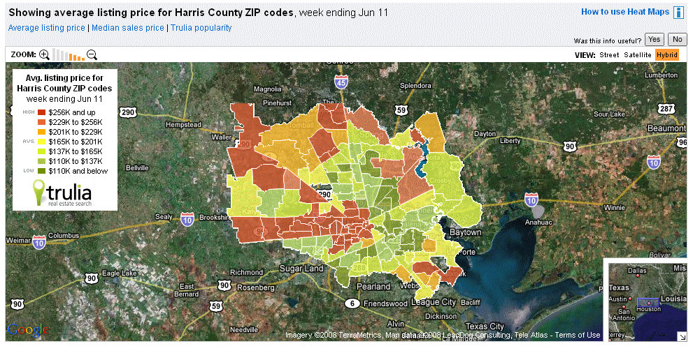
Affordable Housing in Houston: Not Limited to the Fringe
The memo indicates that housing is affordable only on Houston’s fringe. This is absurd and betrays an acute unfamiliarity with Houston housing markets. The referenced map shows house asking prices in Harris County (which is core of the urban area). Affordable housing is to be found throughout the metropolitan area Indeed, the low bound of the highest price category is lower than the median house price in Tauranga. No one would expect the consultant to have expertise on Houston housing markets. It does seem inappropriate, however, for the consultant to be erroneously opining that affordable housing is available only on the fringe
Houston’s "Sprawl:" Like Portland
As for Houston's suburbanization, (pejoratively called "sprawl,") the urban area (urban footprint) is approximately average the density for a US urban area over 1,000,000. It is only 10 percent less dense than Portland, despite that urban area's strong smart growth policies. Houston’s density is virtually the same as that of Dallas-Fort Worth and a quarter higher than that of Boston.
Traffic Congestion: Road Building Made it Better
The memo cites Houston as having some of the nation’s worst traffic congestion. It does --- the latest data shows that Houston ranks 8th in traffic congestion, which is not surprising for the nation’s 6th largest metropolitan area. Houston has done quite well. According to the Texas Transportation Institute (leading authority in the US on the subject), Houston had the worst traffic congestion in the US in the middle 1980s (among urban areas of more than 1,000,000 population). After a strong road building program, traffic congestion was materially reduced (though has increased in more recent years, since the road construction program has not kept up with population growth). By the mid-1990s, Houston had improved to 23rd place.
Since the middle 1990s, population growth has outstripped highway expansion and Houston has risen back to rank 8th in traffic congestion (Houston is one of the three fastest growing metropolitan areas over 5,000,000 population in the high income world). Houston has done better than smart growth Portland over the past 20 years, which has seen its excess peak hour traffic delay (based on the Travel Time Index) rise from approximately 1/4 that of Houston to 3/4 that of Houston.
Houston Traffic Moves Faster than Auckland Traffic
Finally, average travel speeds on the motorway and arterial network in Houston were more than 60 kph in 2002 (latest data from the Texas Transportation Institute). By comparison, according to the New Zealand Travel Time Indicator report, the average peak period travel times on the motorway and arterial network of Auckland was 36 kph in 2007.
Smart Growth Land Use Policy: The Root of New Zealand’s Unaffordable Housing
The report misses the point that New Zealand’s housing affordability loss is the result of overly prescriptive land use planning (smart growth or urban consolidation policy). This connection has been identified by some of the world’s top economists and is detailed in our 4th Annual Demographia International Housing Affordability Survey. The situation was best summed up by former Reserve Bank of New Zealand Governor Donald Brash, writing in the Demographia report: the affordability of housing is overwhelmingly a function of just one thing, the extent to which governments place artificial restrictions on the supply of residential land.. In short, where there are no prescriptive land use policies, housing is affordable. Among the six nations surveyed in our report, there are no exceptions.
Addendum: Understanding US Urban Geography
The memo exhibits the usual (and understandable) confusion about US urban geography. The memo refers to the city of Houston (which is a local government authority or municipality of 2 million population). The referenced housing affordability measures apply to the metropolitan area, which has 5.5 million people. There is also the Houston urban area (or agglomeration), which has more than 4,000,000 people (the difference between the agglomeration and the metropolitan area is that the urban area is the continuous urbanization (or urban footprint), while the metropolitan area includes areas considered in the labor market that are outside the urban area and generally in rural areas. Urban area and metropolitan area are formal designations by the US Bureau of the Census.
Demographia is "pro-choice" with respect to urban development.
People should have the freedom to live and work where and how they like.
CATEGORIES
- California High Speed Rail (21)
- Consumer Warnings (1)
- Demographics (73)
- Economics (76)
- Greenhouse Gas Emissions (46)
- Greenhouse Gas Omissions (44)
- Housing Affordability (36)
- Labor (1)
- Megacities (8)
- Popular Culture (7)
- Rental Car Tours (15)
- Transport (86)
- Urban Policy (112)
RESEARCH AIDS
- Australian Bureau of Statistics
- Central Statistical Office (Eire)
- China Yearbook
- India, Census of
- INSEE (France Nat'l Statistics)
- Japan Statistical Yearbook
- National Statistics (UK)
- OECD Statistics
- Reserve Bank of Australia
- Statistics Canada
- Statistics New Zealand
- UN Climate Change Reports
- UN Population Data
- US Bureau of Econ Analysis
- US Bureau of Labor Statistics
- US Bureau of the Census
LINKS
ARCHIVE
-
▼
2008
(82)
-
▼
June
(8)
- World Urban Areas: Population, Density & Projectio...
- Consultant Memo on Houston Misleads Tauranga Council
- On the Success of Airline Deregulation
- Historic Annapolis Core Threatened by New Urbanist...
- Transit Ridership Increase in Context
- Lucky Honolulu Wasn't Founded on Upper Peninsula: ...
- Alex Marshall's Delusions About Anti-Transit Bias
- GHG Emissions Less in Auto Oriented Suburbs than U...
-
▼
June
(8)
Smart Growth in Athens
